Release History
Elevation Pro
2026.0.10 (November 2025)
- E-Pro News. Provides news about new features, events, tips and more in a workspace panel that displays each time the program is started. Individual Tabs provide a link to a Blog, Training Opportunities and What’s New which provides the release history. The workspace panel can be closed by selecting the X in the upper right corner of the panel. To re-open, choose Help/What’s New.
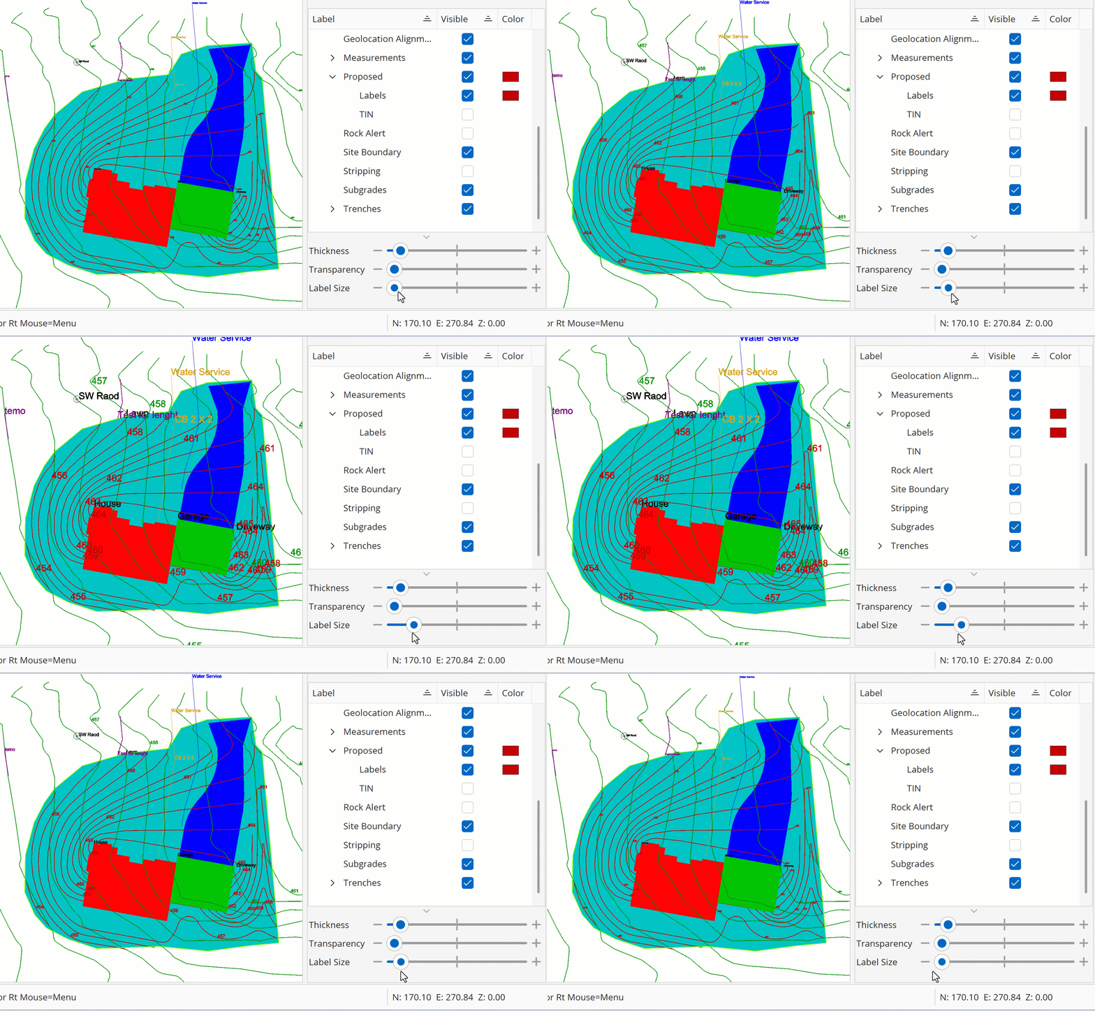
- Adjustable Label Size in all Workspaces. The label size changes are reflected in exports to PDF, CAD, and KMZ.
2025.3.36 (October 2025)
- Visualize your data with the new Cut and Fill Grid view. Gain additional information and insights into your earthwork calculations with our new grid view option, giving you a different tool to analyze and review cut and fill data at a glance.

- Updated learning resources. Solidify your knowledge with the most up-to-date tutorial jobs and user manual content to help you get the most out of the latest features.
- Improvements and Fixes
2025.3 (August 2024)
-
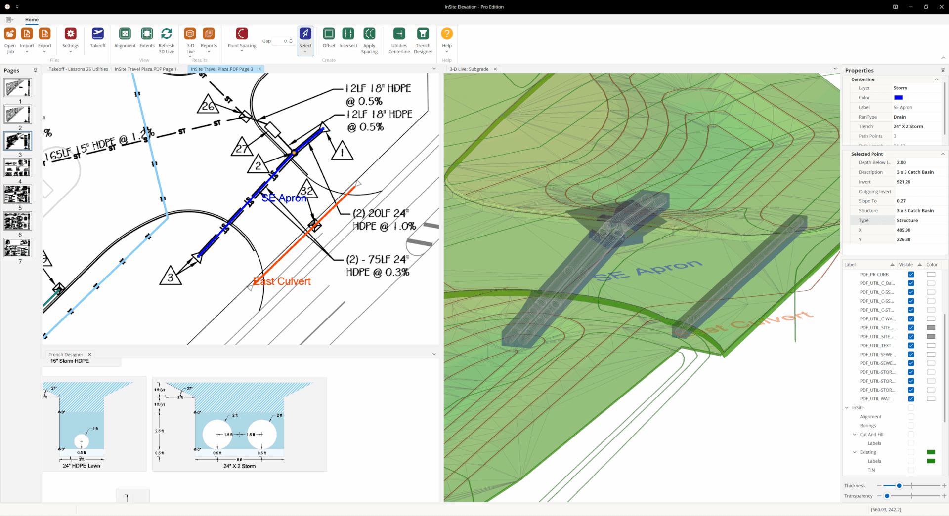
TrenchVision 3D Utility Takeoff. This release delivers complete Trench/Utility Takeoff tools, designed to eliminate tedious manual calculations. Learn More.
- Import & Export. Export once: accurate LandXML units, stable DWG/DGN workflows, and organized KMZ layers stakeholders can act on.
- Performance & Stability. PDF Imports are even better with faster import times, smoother navigation, and enhanced stability mean fewer interruptions, keeping you in flow instead of troubleshooting.
25.0.144 (April 2025)
- Improved visibility of Spot Elevation and Count Item objects
- Optimized default Point Spacing
- Other stability & performance enhancements
25.0.141(March 2025)
- Updated User Manual (version 2025.14) including an updated Appendix with takeoff concepts, instructions for printing a scaled PDF. and more
- Other stability & performance enhancements
25.0.135 (February 2025)
- Updated User Manual (version 2025.11) including new content on Phasing and Google Earth integration and more
- Added legacy support for ‘B’ key to close shapes (same functionality as ‘C’ key)
- Added a Transparency Slider which will allow you to adjust the opacity of all InSite layers at once for any view
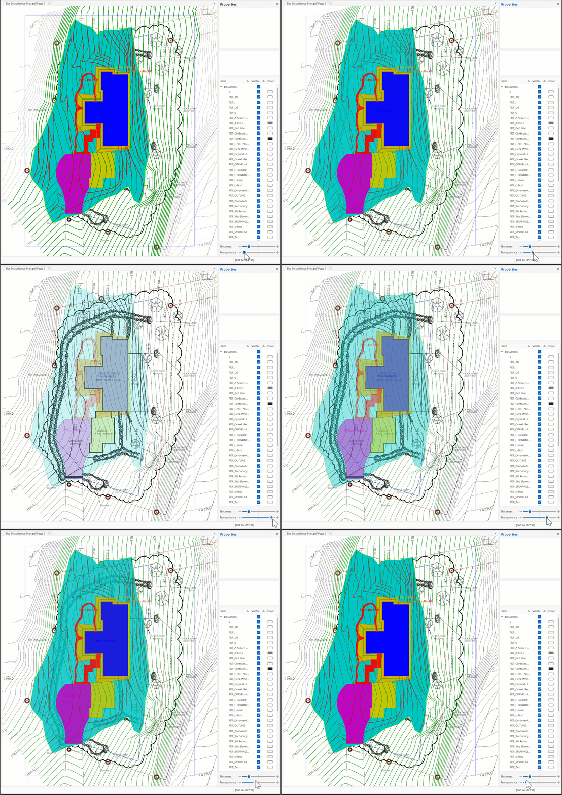
Transparency Slider
- Enabled view panning using Mouse 3 (usually the middle mouse button, or clicking the scroll wheel)
- Other stability & performance enhancements
25.0.125 (February 2025)
- Improved InSite layer line thickness fidelity on PDF/CAD export
- Other stability & performance enhancements
25.0.114 (January 2025)
- Improved DGN import
- Added 3D Live support for Site Boundaries in areas where there are no existing/proposed grades
- Other stability & performance enhancements
25.0.100 (December 2024)
- Faster performance and increased capacities for larger and more complex projects like solar farms, airports, large subdivisions, etc.
- KMZ Export now includes separate layers for better visualization of different elements such as site boundaries, utilities, or structures. Easily manage, analyze, and update specific components without affecting the entire project. Additionally, it improves collaboration by enabling stakeholders to focus on relevant layers individually. Removed white background for KMZ export.
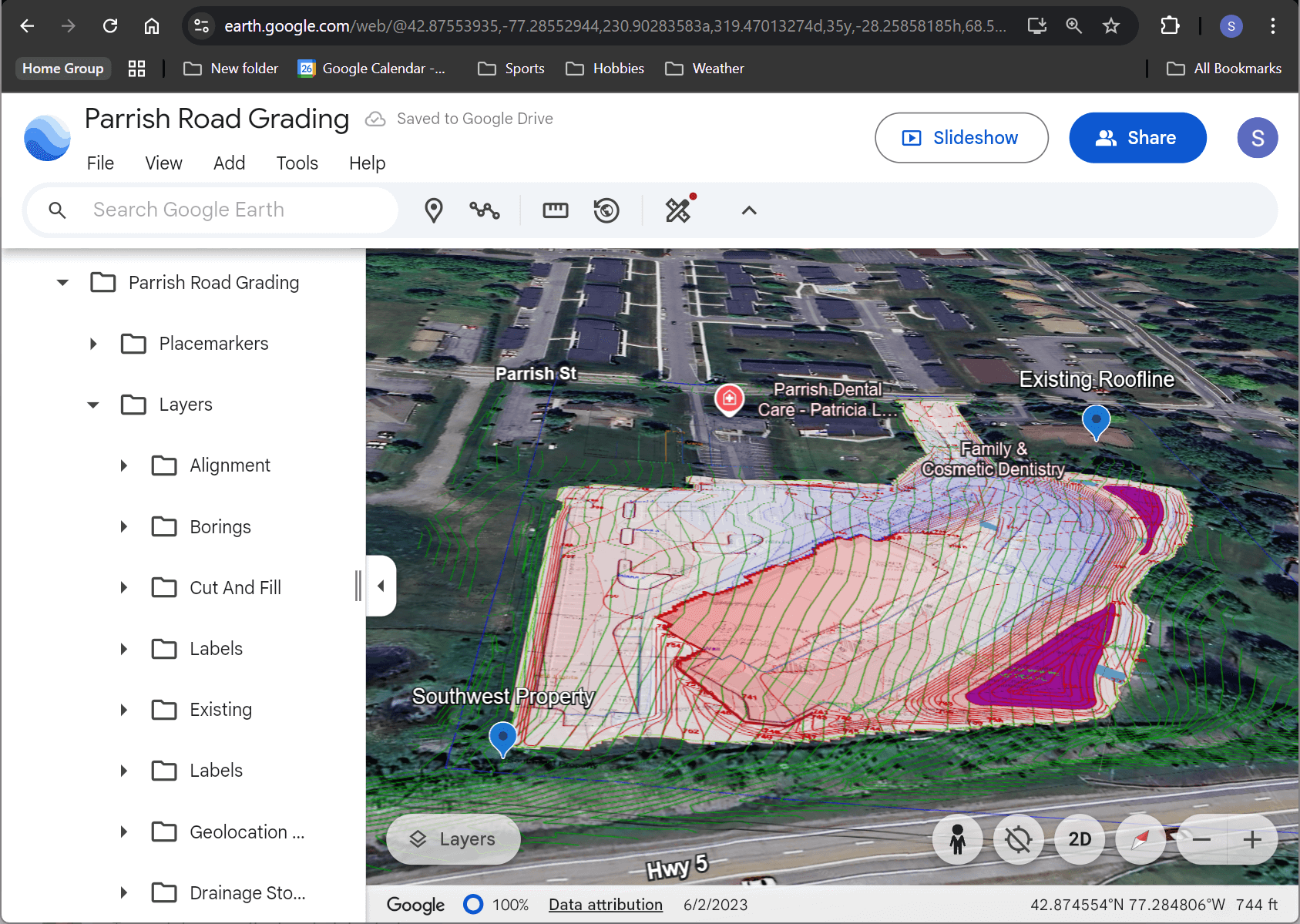
- Improved PDF graphic rendering. Inefficiently rendered PDFs (large) that slowed performance in earlier releases are now fast and smooth.
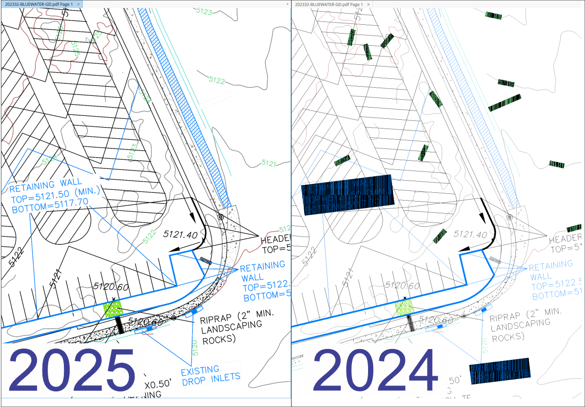
PDF rendering 2025 vs 2024
- A 3D Live that is truly live. Faster and higher quality rendering with an industry exclusive direct data selection, property editing and export. Edit errors in contours, spot elevations, etc. directly from the 3D. Export DWG CAD files directly from any 3D Live surface so that anyone can easily view the 3D surface using DWG TrueView. Watch the video to see it in action.
- Site Boundaries made simpler: Simplify Site Boundary data entry with automated daylight and cutoff boundary detection, ensuring greater accuracy and consistency.
- Improved CAD file compatibility support for the latest versions of AutoCAD and Civil3D.
- DGN File import support for Bentley MicroStation.
- Added a Transparency Slider which will allow you to adjust the opacity of all InSite layers at once for any view.
- Other stability & performance enhancements
2024.3.1 (September 2024)
- Improved compatibility with file replication services (e.g. Dropbox, OneDrive, etc)
- General improvements and bug fixes
2024.1.29 (June 2024)
- Improvements and bug fixes
2024.1.26 (May 2024)
- Added “Help | What’s New“
- Disable auto thaw of DWG layers
- Other improvements and bug fixes
2024.1.25 (April 2024)
- Improved support for DropBox, OneDrive, iCloud, etc., replicated storage for job files
- Other improvements and bug fixes
2024.1.23 (March 2024)
- Auto configure and validate Windows High Performance Graphics configuration
- Improved support for network drives. For more information reference FAQs | InSite Software “Where should my data files be stored for best performance?”
- Save customized Point Spacing settings per job (.insite file)
- Other improvements and bug fixes
- 2024.1.18 (February 2024 2H)
- Fixed issue with Slope Area not being calculated for surfaces with zero area triangles
- Other improvements and bug fixes
2024.1.0 (February 2024)
- New Area Cut and Fill feature- This feature makes calculating cut and fill for any defined region(s) easier. Use vector selection from any PDF or CAD file or any takeoff item including cut or fill contours. Regions can also be freehand drawn. Each uniquely labeled region is stored and recalculated when changes are made to any earthwork features. In the User Manual reference Lesson 20.07.
- Haul Balance Region cut & fills placed on a unique layer now reflects the balance between regions to assist in haul planning. Route distances and regions can be overlayed on PDF’s CAD and KMZ files for export. In the User Manual reference Lesson 20.09.
- New Slope Area feature- Reports now list both the plan view and surface area. This allows faster calculation of retaining walls, ponds, erosion control liners, etc. In the User Manual reference Lesson 20.07.
- Simplified Point Spacing user interface. In the User Manual reference Lesson 10.
- Updated user manual and tutorial files
- Other improvements and bug fixes
2023.1.19 (December 2023)
- Fixed Add To Layer of specific exploded Civil 3D Corridor centerline is creating invalid Sloping Line comprised entirely of Location points
- Fixed Civil 3D DWG with Grading entities fails to import
- Fixed Cross Sections show the water table even if it is 0 depth for all borings
- Other improvements and bug fixes
2023.1.15 (September 2023)
- Fixed issue with the Offset tool not handling entities with duplicate points or self-intersections
- Other improvements and bug fixes
2023.1.13 (June 2023)
- Updated user manual and tutorial files. (Click on “Help”, then “1. User Manual”)
- Only display overall model viewport in imported CAD files
- Fixed issue with Add To Layer and Crossing Window selection creating phantom contour
- Other improvements and bug fixes
2023.1.4 (May 2023)
- Improved use of memory and other resources
- Fixed issue with incorrect viewport for Export PDF/DWG
- Fixed issue in Offset tool to better maintain original points in generated line work
- Fixed PDF Import not importing specific shaded areas from some PDFs
- Other improvements and bug fixes
2023.0.38 (March 2023)
- Slope To Daylight tool- InSite’s offset, slope to daylight and line snap tools allow estimators to take primitive data and turn it into a good surface/take-off. Create intermediate surfaces for complex over-digs, sediment traps, wastewater treatment tank installs, etc. In the User Manual reference Lesson 21.04.
- Dual Offset support for sloping line creation- In the User Manual reference Lesson 11.
- Apply Point Spacing tool. Reference- In the User Manual reference Lesson 10.04
- Borings surface calculations performance improvements, more than 1000x faster
- Offset tool displays path preview- In the User Manual reference Lesson 11.03.
- Improved Civil3D entity support and performance
- Other improvements and bug fixes
2022.2.22 (February 2023)
- Added shading for region between 0 and first contour interval in Cut & Fill contours
- Other improvements and bug fixes
2022.2.19 (December 2022)
- Streamlined and simplified local storage support
- Improved responsiveness of PDF thumbnail viewer for complex PDF pages (no longer blocks opening pages until all in view thumbnails have rendered)
- Other improvements and bug fixes
2022.2.16 (November 2022)
- Fixed issue with handling Length calculated property of legacy (not lightweight) 2D Polyline entities
- Added guard rails to ignore invalid Spot Elevation entities during Import SiteWork Job
- Fixed issue with Cut & Fill contours with uncalculated areas that have no volume
- Other improvements and bug fixes
2022.2.12 (October 2022 2H)
- Added transparency support in PDF Import
- Fixed issue with aligning of rotated DWG files
- Fixed 3D Live Legend is not refreshing until its view is reopened or resized
- Other improvements and bug fixes
2022.2.8 (October 2022)
- Added LandXML Export support for Proposed with Subgrades layer- In the User Manual reference Lessons 23.13 and 23.14.
- Other improvements and bug fixes
2022.2.4 (September 2022)
- KMZ Export feature exports KMZ files to third-party mapping applications like Google Earth, Map Plus, and other geo-browsers with up-to-the-minute job site data. (Click here) See Lesson 27 in User Manual)
- Cut and fill contour map– By presenting the cut/fill information in the form of contours, adjustable to user defined intervals, trends across the site including significant cut or fill, soil erosion risks, and other critical factors can easily be identified. In the User Manual reference Lessons 3.08 and 3.09.
- Newly designed Site Balancer makes it simple to adjust entire sites or individual regions to minimize import or export and lower costs. In the User Manual reference Lesson 25.
- Dynamic sloping lines- In the User Manual reference Lesson 11.
- Updated documentation
- Other improvements and bug fixes
2022.2.1 (August 2022)
- Added Import | Insert From (DWG/DXF) for CAD content feature. In the User Manual reference Lesson 22.
- Added Geolocation Alignment feature. In the User Manual reference Lesson 27.04.
- Area and Length entities now respect Line Width setting in Takeoff/Import Views
- Automatic backup of the current job is created before Modify Document Alignment
- Fixed large coordinate DWG/DXF display issue
- Other improvements and bug fixes
2022.1.42 (July 2022)
- Added support for line width and color controls in the Takeoff view. In the User Manual reference Lessons 8.16 and 8.17.
- Site Boundaries now respect line width settings in Takeoff and Import views
- Increased default line width of Site Boundaries
- Improved auto layout of Cut & Fill Contour labels to reduce overlap
- Automatically hide Stripping and Subgrade layers when Cut & Fill Contour /or Rock Alert layers are enabled
- Other improvements and bug fixes
2022.1.30 (June 2022)
- New RockAlert® feature. In the User Manual reference Lesson 18.08.
- Added transparency support to PDF Export
- Other improvements and bug fixes
2021.3.115 (May 2022)
- Line width support for imported PDF and CAD files
- Other improvements and bug fixes
2021.3.112 (April 2022)
- Added custom layer colors support in Import Views. In the User Manual reference Lesson 8.16.
- Added linework thickness control support in Import Views. In the User Manual reference Lesson 8.17.
- Significant performance improvement importing files with a large number of layers
- Improved the visibility of Spot Elevation symbols
- Spot Elevation, Boring, and Item Count symbols are now correctly sized in metric jobs
- Added support for legacy Civil 3D AECC Contour entity
- Other improvements and bug fixes
2021.3.92 (March 2022)
- Added new Lesson 24 Job Phasing. In the User Manual reference Lesson 24.
- Updated tutorial sample jobs
- Improvements and bug fixes
2021.3.79 (February 2022)
- Added LandXML Export for Existing and Proposed surfaces. Click here to learn more. In the User Manual reference Lessons 23.13 and 23.14.
- Improvements and bug fixes
2021.3.63 (January 2022 2H)
- Added support for mitered fillets for Offset Tool. In the User Manual reference Lesson 21.03.
- Improvements and bug fixes
2021.3.60 (January 2022)
- Fixed magnetic cursor is only snapping to ends of 3D entities
- Fixed issue blocking ability to access Cut & Fill Report
- Improvements and bug fixes
2021.3.53 (December 2021)
- Offset Tool enhancements to support self-intersecting paths and multiple path results
- Fixed issue in Import SiteWork Job resulting in incomplete import
- Improvements and bug fixes
2021.3.44 (December 2021)
- Significant performance improvement for import of large PDFs
- Offset Tool multi selection support. In the User Manual reference Lesson 21.
- Updated tutorial/manual and sample jobs
- Improvements and bug fixes
2021.3.26 (November 2021)
- Multi selection Add To Layer, Delete (bulk import/delete operations).In the User Manual reference Lesson 22 CAD Import.
- Site Phasing support. In the User Manual reference Lesson 24: Job Phasing.
- Added support for more Civil 3D entities
- Direct Add To Layer support for Civil 3D TIN Surfaces
- Significant selection performance improvements for documents that contain Civil 3D content
- PDF Import containing embedded images rendering fix
- Updated documentation and tutorials covering Multi-Select and CAD/Bulk import, Improving Triangulation, Job Phasing, and New Sloping Lines Method
- Improvements and bug fixes
2021.0.283 (October 2021)
- Site Balancer 2.0 with contouring, 3D Live support, undo/redo, reporting on intermediate results. Easily adjust site grades to achieve an acceptable balance, or adjust either an entire site or individual areas. Click here to learn more. In the User Manual reference Lesson 25: Dynamic Site Balancer.
- Improvements and bug fixes
2021.0.263 (September 2021)
- Improvements and bug fixes
2021.0.247 (August 2021)
- Improvements and bug fixes
- Moved Update Available user interface from badges to ribbon bar button
- Rotated DWG world coordinates alignment fix
2021.0.238 (July 2021)
- Improvements and bug fixes
- Area, length, item count persistent color, layer, item label for even faster takeoffs. Click here to learn more. In the User Manual reference Lesson 20: Area, Length, Production Analysis.
- Improved cross sectional views with export to PDF. In the User Manual reference Lesson 19: Viewing Cross Sections.
- Soil boring entry for cuts by strata. Add a row for each strata, add shrinkage (re-compaction) and expansion (loose haul) percentages and the depths to each strata layer. Add shrinkage and swell factors to calculate bank, recompacted and loose haul volumes. Click here to learn more. In the User Manual reference Lesson 18.07: Results with Borings.
- Water table entry. In the User Manual reference 18.05: Water Table.
- Strip to strata. In the User Manual reference Lessons 12.02 and 18.04.
2021.0.60 (June 2021)
- Open multiple PDF files and pages simultaneously. Click here to learn more. In the User Manual reference Lesson 6.04: Opening an Image File and Lesson 7.07: Combining CAD and PDF Files.
- Easy multi-page PDF alignment with perfect accuracy. Align an import file to another open aligned PDF by snapping to common points. Click here to learn more. In the User Manual reference Lesson 7: Basic PDF Alignment.
- Major enhancements to area, length & item count
- Undo (Ctrl-Z) and redo (Ctrl-Y) capability on all features. In the User Manual reference Lesson 1.09: Hot Keys.
- Edit InSite data in any import view
- Easily share takeoff results to mobile devices via save As PDF to include toggleable InSite layers (e.g., EG, PG, SG, C&F Shading, Areas/Lengths, etc.) and the original PDF document. In the User Manual reference Lesson 26 PDF & CAD Export.
- Roller mouse zoom and pan on all views
- All-New CAD engine supports latest AutoCAD files
- Support for rotated PDFs
- Click and drag to modify location or shape of linework (e.g., edit the site boundary smaller/bigger by dragging nodes) – In the User Manual reference Lesson 9.05: Resizing a Boundary or Lesson 23.07: Move a Node.
- Dynamic sloping lines (i.e., editing elevation points along a sloping line will re-calculate interpolated location points) – In the User Manual reference Lesson 23.09.
- Adjustable point spacing for all linework. (i.e., weeding & supplementing)
- Offset linework from any feature entered (e.g., EG, PG, SG, etc.)
- Click perimeters to quickly edit stripping/subgrade details
- Export surfaces to CAD programs and GPS machine control via save as .DWG to include the original CAD file, model (TIN) surface or any other feature layer (e.g., EG, PG, SG, etc.)
- 4K monitor support
- And many more
2020.0.30 (March 2020)
- Single my job.insite file that works well on cloud file sharing tools like DropBox, OneDrive, etc.
- Improved file management with pinned recent jobs list
- Dockable workspace panels with improved support for multiple monitors