Streamlining Utility Takeoffs with TrenchVision 3D
October 8, 2025
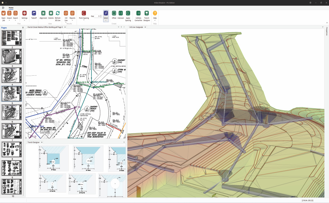 TrenchVision 3D, a powerful new feature available to Elevation Pro subscribers, transforms utility takeoff and earthwork calculation for estimators in the grading industry. This innovation helps earthwork professionals save time, increase accuracy, and win more bids by simplifying the often-tedious calculations for sanitary, storm, and other utilities.
Elevation Pro leads the industry with exclusive capabilities that include the ability to combine multiple documents (PDF, CAD, data collector, drone topo, Google Earth, etc.) into a comprehensive takeoff. TrenchVision 3D builds on this simple and fast interface and uses solid modeling to provide unmatched accuracy. Users can now align utility plans with all grading data, enabling more detailed and precise takeoffs.
TrenchVision 3D offers flexible trench configurations supporting multiple trench shapes and multiple pipes per trench. When soil boring data is entered, it provides excavation calculations by stratum and precise backfill volumes for bedding, cover, and backfill, adapting to changing storm run depths.
The feature provides clear visuals to immediately illustrate the full scope of work and identify pipe collisions before they become costly issues. Powerful reporting capabilities include detailed excavation and backfill quantities, pipe lengths, structure heights, and breakdowns by adjustable depth brackets (e.g., 3-5’, 5-7’, etc.) for efficient production planning.
Results can be exported seamlessly to all bidding applications and graphics to PDF, DWG, LandXML, and Google Earth, integrating smoothly into existing workflows. TrenchVision 3D redefines what is possible, becoming an indispensable tool for enhancing efficiency and precision in utility projects.
The original article appeared in the October 2025 issue of Construction Business Owner