Feature Tour
Elevation Pro Benefits
InSite Elevation Pro delivers powerful, easy-to-use tools that enable grading professionals to produce accurate takeoffs and GPS machine control models…
Click Here
Merging Site Data
Modern sitework takeoff relies on data from multiple sources. Elevation Pro’s exclusive ability to open multiple PDF, CAD, drone, Google…
Click Here
PDF & CAD Import
Start a dirt takeoff by importing existing and proposed surface data. Elevation Pro quickly captures fully vectorized information—even dashed contours—for…
Click Here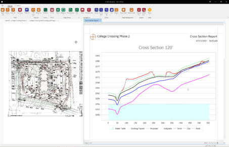
Build a Dirt Takeoff
Building a Takeoff continues after adding the existing & proposed grades. Borings can be optionally added by completing the boring…
Click HereResults that Prove
The results are comprehensive and easy to share—cut by strata, backfill quantities, pipe lengths, structure heights, and adjustable cut bracket…
Click Here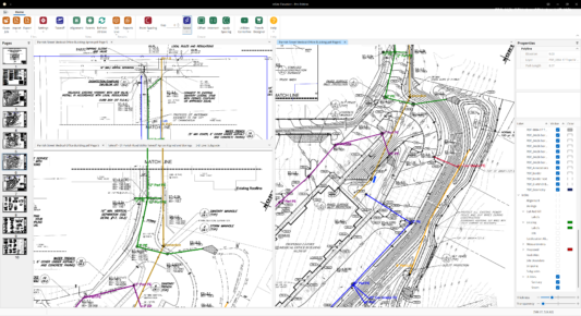
Utility Takeoff
TrenchVision 3D™ quickly and accurately provides excavation and backfill quantities for sanitary and storm sewers, water, electrical and gas service,…
Click Here
Google Earth Export
With InSite Elevation Pro, send the aligned KMZ file to your mobile device. As you walk on the job site,…
Click Here
Additional Pro Tools
InSite Elevation Pro helps grading contractors produce fast, accurate takeoffs with clear visual validation every step of the way. Work…
Click Here
Slope Area
Accurate slope area calculation is not just about numbers; it’s about ensuring project success. Estimating materials for projects like pond…
Click HereGPS Machine Modeling
Elevation Pro leverages triangulation—the same core method used by modern GPS grading systems—to build highly accurate surface models. This means…
Click Here